British & Commonwealth Military Badge Forum

Recent Books by Forum Members


Go Back   British & Commonwealth Military Badge Forum > Everything Else > Other Military Topics

 Other Pages: Galleries, Links etc.
Glossary  Books by Forum Members     Canadian Pre 1914    CEF    CEF Badge Inscriptions   Canadian post 1920     Canadian post 1953     British Cavalry Badges     Makers' Marks    Pipers' Badges  Canadian Cloth Titles  Books  SEARCH
 
Reply
 
Thread Tools Display Modes
  #1  
Old 22-01-14, 08:02 PM
irish's Avatar
irish irish is offline
Member
 
Join Date: Apr 2010
Location: Illinois USA
Posts: 1,996
Default Captured German Map.

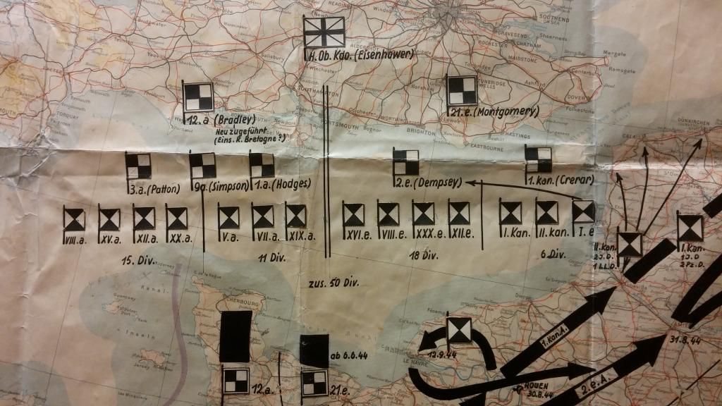
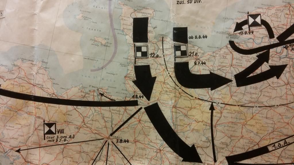
This map was brought home after the war by a U.S. 5th Armored Division officer. It is roughly 42" x 60". It appears to be a situational map showing the Allied Armies and Groups along with the commanders. From pre D-Day and following their movements to date. It also shows the landing in southern France. If you look at the northern area you will see the "Luft Landings" Airborne landings in the Arnhem "Market Garden" operation. Those entries appears to be the latest "chronological" entry on the map. This would be the units approximate dispositions prior to the end of 1944 and the "Battle of the Bulge" Interesting piece. All of the flags etc are hand cut individual pieces cut and applied to the map. enjoy

__________________
"We must make our mistakes quickly"
Major General George Alan Vasey CB, CBE, DSO and Bar
New Guinea 1942

Last edited by irish; 22-01-14 at 08:19 PM.
Reply With Quote
  #2  
Old 22-01-14, 08:06 PM
irish's Avatar
irish irish is offline
Member
 
Join Date: Apr 2010
Location: Illinois USA
Posts: 1,996
Default

More


__________________
"We must make our mistakes quickly"
Major General George Alan Vasey CB, CBE, DSO and Bar
New Guinea 1942
Reply With Quote
  #3  
Old 22-01-14, 08:07 PM
irish's Avatar
irish irish is offline
Member
 
Join Date: Apr 2010
Location: Illinois USA
Posts: 1,996
Default

Last


__________________
"We must make our mistakes quickly"
Major General George Alan Vasey CB, CBE, DSO and Bar
New Guinea 1942
Reply With Quote
  #4  
Old 22-01-14, 09:29 PM
Mike Jackson's Avatar
Mike Jackson Mike Jackson is offline
Member
 
Join Date: Feb 2008
Posts: 6,329
Default

Quote:
Originally Posted by irish View Post
This map was brought home after the war by a U.S. 5th Armored Division officer. It is roughly 42" x 60". It appears to be a situational map showing the Allied Armies and Groups along with the commanders. From pre D-Day and following their movements to date. It also shows the landing in southern France. If you look at the northern area you will see the "Luft Landings" Airborne landings in the Arnhem "Market Garden" operation. Those entries appears to be the latest "chronological" entry on the map. This would be the units approximate dispositions prior to the end of 1944 and the "Battle of the Bulge" Interesting piece. All of the flags etc are hand cut individual pieces cut and applied to the map. enjoy

Fascinating. I was pleased to see at least three deception formations subordinate to 21 Army Group on the first image - 16 British Corps, 18 British Inf Div (they should have known that ceased to exist in Singapore in 1942) and 6 Can Div. Mike
Reply With Quote
  #5  
Old 23-01-14, 01:04 PM
irish's Avatar
irish irish is offline
Member
 
Join Date: Apr 2010
Location: Illinois USA
Posts: 1,996
Default

Thanks for that input Mike. So the number of divisions is over stated?
__________________
"We must make our mistakes quickly"
Major General George Alan Vasey CB, CBE, DSO and Bar
New Guinea 1942
Reply With Quote
Reply


Posting Rules
You may not post new threads
You may not post replies
You may not post attachments
You may not edit your posts

BB code is On
Smilies are On
[IMG] code is On
HTML code is Off

Forum Jump

mhs link

All times are GMT. The time now is 06:52 AM.


Powered by: vBulletin
Copyright ©2000 - 2024, Jelsoft Enterprises Ltd.